Volumetrics
Explore our comprehensive volumetric services for accurate stockpile measurement and cut and fill analysis.

Get Volumetric Measurements with Drones: A Better Way To Measure
Volumetrics play a crucial role in various industries, providing accurate measurements for stockpile management and cut and fill analysis. By utilizing state-of-the-art drone technology, we offer a more efficient and precise way to measure stockpiles and analyze cut and fill. With our drone volumetric services, you can streamline your operations, track inventory, optimize resources, and make informed decisions to drive success in your industry.
Stockpile Measurements
Our stockpile measurement service utilizes calibrated, survey-grade, drone LiDAR and photogrammetry to accurately measure and track stockpile volumes. With our precise measurements, you can optimize your inventory management and make better informed decisions.
No Interruptions
Tracking inventory volume with a drone means no interruptions to your work. We fly and your team stays working below.
Tailored Data Insights
Receive tailored reports that fit your specific business needs, providing clear insights and actionable data to support strategic decisions.
Timestamped Reporting
Benefit from our timestamped data collection, ensuring each inventory report is accurately aligned with specific dates and times.
.webp)
.webp)
.webp)
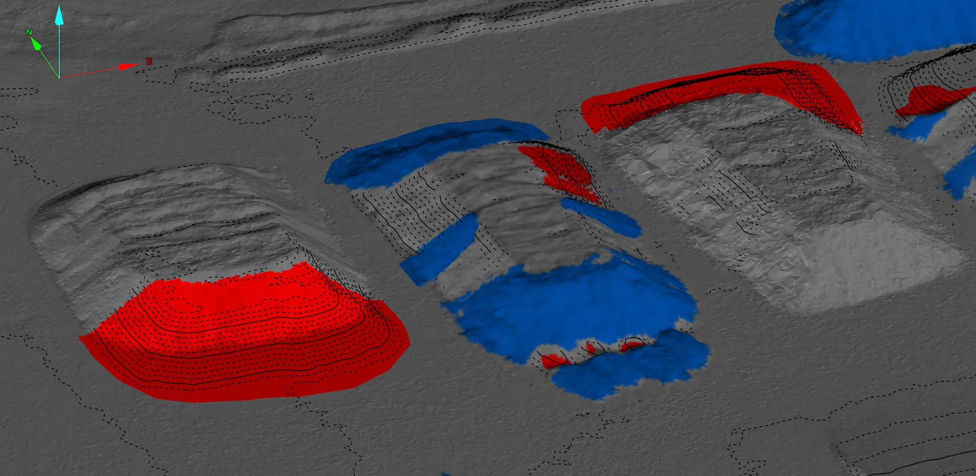
Cut & Fill Analysis
Leverage our comprehensive cut and fill analysis to efficiently manage earthmoving tasks and optimize material usage. Ensure cost-effective project execution with our detailed, accurate assessments.
Precision Ground Analysis
We don't just estimate or rely on inconsistent truck counting for volume. Our cut fill analysis is a true measurement of ground surface change between surveys.
Optimized Resource Allocation
Analyze and adjust material distribution to minimize waste and reduce costs, crucial for maintaining budget and environmental goals.
Enhanced Project Efficiency
Speed up project delivery with precise and rapid site surveys, ensuring your projects adhere to schedules and reduce the risk of costly overruns.
Discover the Power of Drones for Volumetrics
Our volumetric services provide accurate stockpile measurements and cut and fill analysis, helping you optimize your operations and maximize efficiency. With our state-of-the-art drone technology and advanced software, we deliver precise data and actionable insights.
Fast
Our drone-based stockpile measurement service allows you to accurately calculate the volume of materials in your stockpiles. By eliminating the need for manual measurements, we save you time and resources while ensuring data accuracy.
Accurate
Our cut and fill analysis service helps you optimize earthwork operations by providing detailed information on the volume of material to be excavated or added to achieve desired site levels. This enables you to minimize costs and reduce project timelines.
Cost-Efficient
Our volumetric services are tailored to various industries including construction, mining, and agriculture. Whether you need to measure stockpiles for inventory management or analyze earthwork volumes for site planning, we have the expertise to meet your specific needs.
Volumetrics: Accurate Measurements for Your Industry
Our volumetric services provide precise stockpile measurement and cut and fill analysis for industries such as mining, construction, and agriculture.

Mining
Maximize resource management and mine planning with SmartDrone's advanced volumetric analysis. Our precision LiDAR mapping captures the minute details of your site, delivering critical data that helps you monitor production and streamline operations

Construction
Build with confidence by leveraging detailed topographic data tailored for construction excellence. Our technology ensures accurate cut-and-fill calculations, aiding in precise grading and efficient material allocation. All this complemented by day-of high resolution orthomosaics to monitor progress on site.

Solid Waste
Optimize your waste management with SmartDrone's volumetric solutions. Our high-resolution drone imaging and LiDAR technology give you the power to accurately measure landfill volumes, plan for future capacity, and maintain environmental compliance. Enhance your waste operations with data-driven precision for a greener tomorrow.
Discover the Power of Drones for Volumetrics
Discover how our drone-based volumetric services transform the way you measure and analyze land. Fast, accurate, and cost-efficient volume data collection when and where you need it.
Fast
Experience rapid mobilization and swift data collection with SmartDrone Volumetrics. Our industrial mapping drones streamline your volumetric surveying process, delivering detailed results in a fraction of the time it takes traditional methods.
Accurate
Precision is at the core of SmartDrone Volumetrics. Utilizing cutting-edge drone LiDAR and photogrammetric technology ensures the highest accuracy in mapping and measurement, giving you the confidence to make decisions based on data you can trust.
Cost-Efficient
Cut costs without cutting corners with SmartDrone's efficient volumetric solutions. Our drones cover vast areas quickly, reducing the need for multiple on-ground survey teams and project delays. Minimizing labor and maximizing technology with SmartDrone Volumetrics.
Get On-Demand Drone Volumetrics
Get a free quote for our drone volumetric services and experience a better way to measure.

